- Published on
- • Updated on
Scan to BIM: Complete Guide to Process, Cost, and Accuracy (2026)
Scan to BIM is the process of capturing an existing building or infrastructure asset using laser scanning or photogrammetry, then converting that scan data into a structured BIM model. In Singapore, Scan to BIM is used primarily for facilities management, digital twin creation, and regulatory compliance for Alteration & Addition (A&A) works above 5,000 sqm. A typical project for a 5,000 sqm building costs approximately $20,000 and takes one to two months.
When Do You Need Scan to BIM?
The most common reason building owners commission Scan to BIM is to create a digital twin of an existing facility. Older buildings often have incomplete or outdated documentation, and scanning is the most cost-effective way to produce an accurate, data-rich model for ongoing facilities management.
Beyond FM and digital twins, common triggers include:
- Regulatory compliance: A&A works above 5,000 sqm in Singapore require BIM submissions to the authorities. For buildings without existing BIM models, Scan to BIM is the practical path to compliance.
- Missing design documentation: when original drawings have been lost, modified beyond recognition, or were never digitised, a scan provides the baseline for reconstruction.
- As-built verification: overlaying scan data on the design BIM model to generate deviation reports that identify discrepancies between design intent and what was actually built.
- Heritage and conservation: capturing the precise geometry of heritage structures where manual measurement would be impractical or risk damage.
Which Method Should I Choose: LiDAR or Photogrammetry?
| Feature | LiDAR | Photogrammetry |
|---|---|---|
| Technology | Laser pulses to measure distances | Photos to reconstruct 3D models |
| Accuracy | High – ideal for detailed geometry | Moderate – image-dependent |
| Data Output | Point clouds (.e57, .laz, .ptx) | Meshes (.obj, .stl, .3mx) + textures |
| Environmental Conditions | Works in low light and cluttered environments | Requires good lighting |
| Cost | Higher – uses specialized scanners | Lower – uses standard cameras/drones |
| Processing Time | Faster collection, slower cleanup | Slower collection, faster mesh output |
| Use Cases | Infrastructure, topography, clash detection | Site context, architectural surveys, heritage scans |
| Vegetation Penetration | Can capture through foliage | Limited penetration |
LiDAR generally produces higher accuracy point clouds. It's better for modeling mechanical systems or verifying structural works. On the other hand, photogrammetry offers a lower-cost, fast turnaround option for creating presentation-ready mesh models or capturing large outdoor sites.
What Does the Scan to BIM Workflow Look Like?
Step 1: Surveying
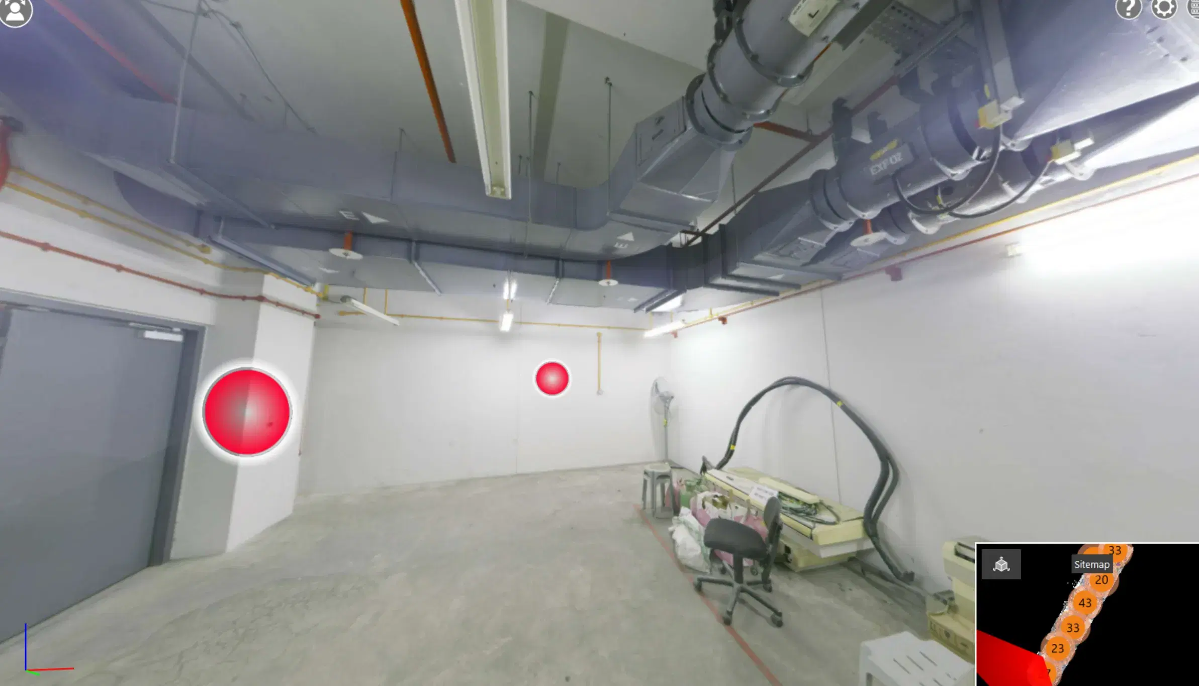
A registered surveyor brings precision LiDAR scanners on-site to capture the as-built condition of the asset with sub-10mm accuracy. The scanners produce raw point cloud files that are geo-coordinated to the Singapore SVY21 coordinate system. Alongside the LiDAR capture, surveyors also take 360-degree photos of the site, which provide additional visual detail that point clouds alone cannot capture.
For concealed elements such as hidden MEP services, the surveyor captures what is accessible during this phase. Where elements are fully concealed, existing as-built plans may be used as a basis for comparison, although these documents are often difficult to locate as they tend to be lost or modified over time.
Step 2: Point Cloud Processing
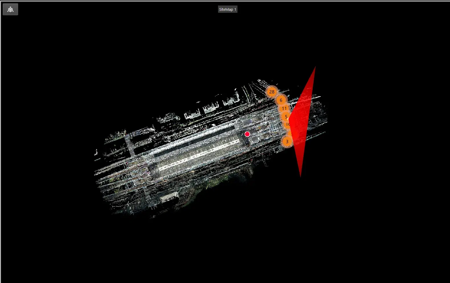
The raw scan files are processed using software such as Autodesk ReCap, which is commonly used in Singapore due to its seamless integration with Autodesk Revit, the most widely adopted BIM software locally. During processing, the BIM team:
- Registers multiple scans into a single coordinated dataset
- Cleans the data to remove noise and artefacts
- Segments the ReCap files into manageable sections to prevent workstation overload during modelling
This step ensures the point cloud is accurate, navigable, and ready for the modelling team to work with.
Step 3: BIM Modelling
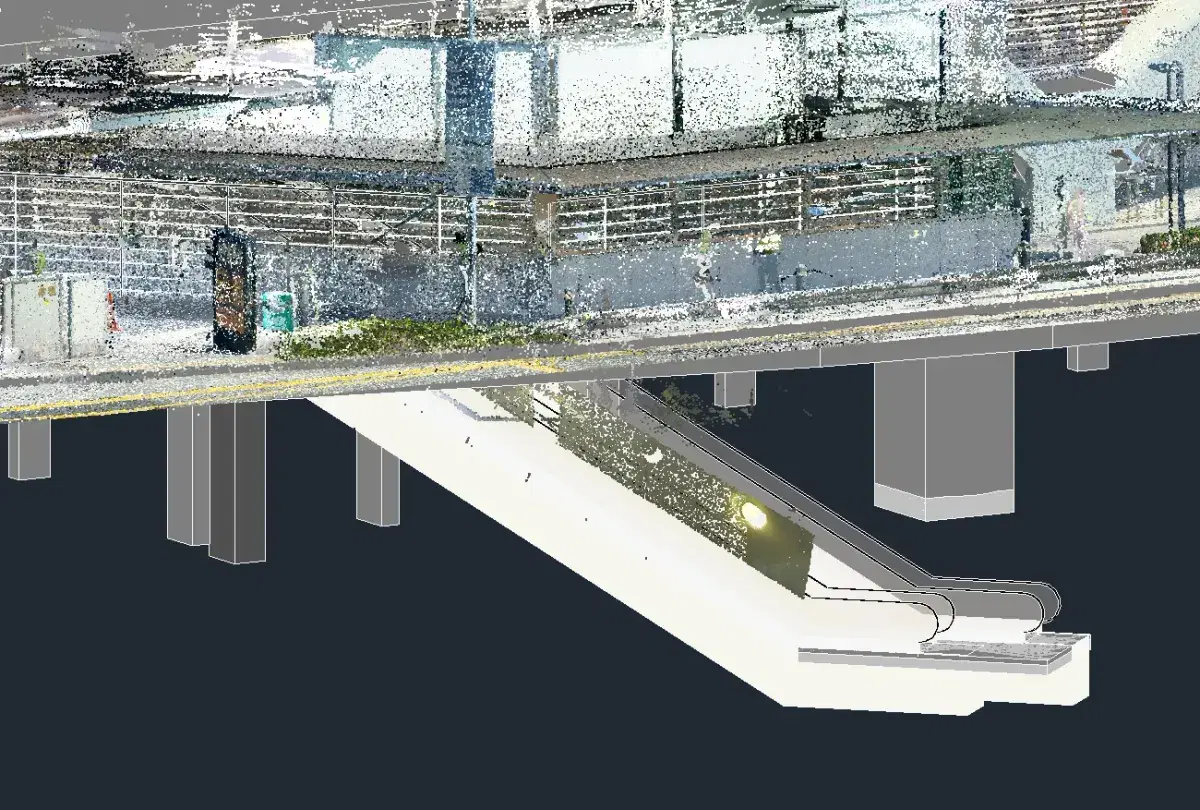
The BIM team builds the model by cross-referencing the processed point cloud with the 360-degree photos captured during the survey. The photos capture surface finishes, signage, equipment labels, and other details that are difficult to extract from a point cloud alone.
Where as-built plans are available, the team uses them as a reference for comparison, though older plans may not reflect the current state of the building. The final deliverable is typically a LOD 300 Revit model, but clients can request additional information layers such as COBie data for facilities management or IFC+SG parameters for CORENET X compliance.
How Much Does Scan to BIM Cost in Singapore?
A Scan to BIM project for a 5,000 sqm building in Singapore typically costs around $20,000 in total, broken down into two main components:
| Component | Typical Cost (5,000 sqm) | What Drives Cost Up |
|---|---|---|
| Surveying (data capture) | ~$10,000 | Capturing hidden MEP services; complex site access; restricted airspace requiring special permits |
| BIM modelling | ~$10,000 | Higher level of information requirements such as IFC+SG for CORENET X or COBie formatting for FM handover |
Costs scale with building size, complexity, and the level of information required in the final model. A straightforward architectural scan of an open-plan commercial space will cost less than a detailed survey of a facility with extensive concealed mechanical and electrical services.
For context on broader BIM implementation costs, see our BIM cost breakdown.
How Long Does Scan to BIM Take?
A 5,000 sqm project typically takes one to two months end-to-end, from initial site survey to final BIM model delivery. This includes data capture, point cloud processing (typically one to three working days), and BIM modelling.
Timelines can extend beyond this due to factors outside the project team's control, including:
- Permitting: sites with restricted airspace or security-sensitive locations require permits that can add weeks to the schedule
- Site access: occupied buildings may require phased scanning around operating hours
- Scope changes: discovery of previously unknown MEP services or structural conditions during the scan
Larger or more complex facilities take proportionally longer. The modelling phase is typically the longest, particularly when the scope includes detailed MEP services or high level-of-information requirements.
Does Scan to BIM Meet CORENET X Requirements?
Scan to BIM captures the geometry of an existing building accurately, but CORENET X submissions require IFC+SG parameters that a scan alone cannot provide. These parameters include room classifications, GFA data, accessibility compliance, and agency-specific property sets that are part of the IFC+SG standard.
For most existing buildings, this creates a practical challenge: the assets were developed years ago, and the original design information needed to populate these parameters has often been lost.
The recommended approach is to develop the BIM model from the scan for geometric accuracy first, then mandate the population of IFC+SG parameters in contracts for future A&A works. This separates the immediate value of having a digital model from the longer-term goal of full regulatory compliance. A Professional Engineer (PE) is required to validate the details before any CORENET X submission.
This is a fundamentally different workflow from new-build projects, where IFC+SG parameters are populated during the design process. For scanned buildings, the information gap between what the scan captures and what CORENET X requires must be bridged through professional validation and contractual obligations.
What LOD Do You Get from Scan to BIM?
Most Scan to BIM projects deliver a LOD 300 model, which captures the geometry of building elements with sufficient accuracy for coordination, spatial planning, and regulatory submissions.
The exception is facilities management. When the goal is to create a single source of truth for ongoing building operations, LOD 500 may be required. This goes beyond geometry to include maintenance history, manufacturer details, warranty information, and equipment specifications. For example, an international casino operator commissioned LOD 500 models across their portfolio because their facilities undergo renovation cycles every three to five years. They needed to track details such as when each chiller unit was last serviced, who manufactured it, and when the warranty expires.
The LOD is driven by the client's end-use of the model, not by the scan itself. A LiDAR scan captures the same geometric data regardless of the target LOD. The difference is in how much information is added to the model during the BIM modelling phase.
What Software Is Used for Scan to BIM?
The typical Scan to BIM toolchain in Singapore follows the Autodesk ecosystem:
| Phase | Software | Purpose |
|---|---|---|
| Processing | Autodesk ReCap | Registering, cleaning, and segmenting point cloud data. Chosen for its seamless integration with Revit. |
| Modelling | Autodesk Revit | Building the BIM model from the processed point cloud. The most widely adopted BIM software in Singapore. |
| Review & collaboration | Forma for Construction | Reviewing the model, deep linking to 2D documentation such as manufacturer specifications, and enabling large BIM teams to collaborate in an integrated environment. |
Forma for Construction is particularly valuable for asset owners because it allows them to link BIM elements directly to supporting documentation such as maintenance manuals, equipment specifications, and compliance certificates, creating a connected digital record that extends well beyond the 3D model.
Scan to BIM vs As-Built Drawings: What's the Difference?
As-built drawings record what was designed or last documented, which may have been years or even decades ago. Buildings get modified over time. Walls are moved, equipment is replaced, and services are rerouted. These changes are rarely reflected in the original documentation. As-built drawings are a snapshot of intent at a point in time, not a record of current conditions.
Scan to BIM captures what is actually there today. A LiDAR scan does not rely on historical records or assumptions about what was built. It measures the physical asset as it exists, producing a model that reflects current geometry with sub-10mm accuracy.
For any project where decisions depend on the actual condition of a building, whether renovation planning, FM system setup, compliance submissions, or space reconfiguration, scanning is the more reliable starting point. As-built drawings can supplement the scan where they are available, but they should not be treated as the primary source of truth for an existing facility.
Should I Use LiDAR or Photogrammetry for Scan to BIM?
Use LiDAR when the output feeds into engineering workflows: structural verification, MEP coordination, clash detection, or deviation analysis against design models. LiDAR point clouds achieve 2 to 5 millimetre accuracy, which is the baseline for any work where dimensions are contractually or regulatory significant. If the scan will be used for CORENET X submissions or as-built documentation, LiDAR is the default choice.
Use photogrammetry when the primary purpose is visual: stakeholder presentations, site context models, heritage documentation, or marketing material such as virtual tours. Photogrammetry is faster to capture, lower cost, and produces textured mesh models that look better on screen. It is not suitable for work where precise measurements drive design or compliance decisions.
For projects that require both, a common approach is to run a terrestrial LiDAR scan for the building interior and a drone photogrammetry capture for the external site context, then merge the two datasets during processing.
Frequently Asked Questions

Related Articles
Virtual TOP (VTOP) Singapore: A Main Contractor's Guide
What Virtual TOP is, whether it is mandatory, which projects qualify, the camera BCA expects, the five-step process, and which platform to use.
BIM for Project Owners: Benefits and Use Cases
How BIM gives a project owner visibility, cost control, and faster decisions across the lifecycle, even when the project is already over budget.
BIM Collaborate Pro Is Now Forma: What Changed (2026)
Autodesk renamed ACC and BIM Collaborate Pro to Forma for Construction in March 2026. See the full name mapping, module comparison, and SGD 1,700/yr pricing.